
Mapa topográfico Municipal Unit of Sparta
Mapa interactivo
Haga clic en el mapa para ver la altitud.
Acerca de este mapa
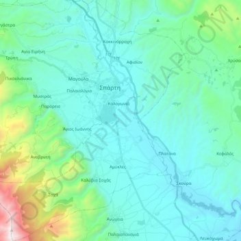
Nombre: Mapa topográfico Municipal Unit of Sparta, altitud, relieve.
Altitud media: 450 m
Altitud mínima: 113 m
Altitud máxima: 2.206 m
Otros mapas topográficos
Haga clic en un mapa para ver su topografía, su altitud y su relieve.
Ευρώτας
Greece > Peloponnese, Western Greece and the Ionian > Laconia Regional Unit
Ευρώτας, Laconia Regional Unit, Peloponnese Region, Peloponnese, Western Greece and the Ionian, Greece
Altitud media: 656 m
Lagia
Greece > Peloponnese, Western Greece and the Ionian > Laconia Regional Unit > East Mani Municipal Unit
Lagia, East Mani Municipal Unit, Municipality of East Mani, Laconia Regional Unit, Peloponnese Region, Peloponnese, Western Greece and the Ionian, 230 71, Greece
Altitud media: 317 m
Sparta
Greece > Peloponnese, Western Greece and the Ionian > Laconia Regional Unit
Sparta, Municipality of Sparta, Laconia Regional Unit, Peloponnese Region, Peloponnese, Western Greece and the Ionian, 231 00, Greece
Altitud media: 198 m
Monemvasia
Greece > Peloponnese, Western Greece and the Ionian > Laconia Regional Unit
Monemvasia, Municipality of Monemvasia, Laconia Regional Unit, Peloponnese Region, Peloponnese, Western Greece and the Ionian, Greece
Altitud media: 7 m
Sparta
Greece > Peloponnese, Western Greece and the Ionian > Laconia Regional Unit > Municipality of Sparta > Χαρίσιο
Sparta, Τριακοσίων, Χαρίσιο, Municipality of Sparta, Laconia Regional Unit, Peloponnese Region, Peloponnese, Western Greece and the Ionian, 23100, Greece
Altitud media: 214 m
Municipality of Sparta
Greece > Peloponnese, Western Greece and the Ionian > Laconia Regional Unit
Municipality of Sparta, Laconia Regional Unit, Peloponnese Region, Peloponnese, Western Greece and the Ionian, Greece
Altitud media: 699 m
Molai
Greece > Peloponnese, Western Greece and the Ionian > Laconia Regional Unit > Molai
Molai, Municipality of Monemvasia, Laconia Regional Unit, Peloponnese Region, Peloponnese, Western Greece and the Ionian, 230 52, Greece
Altitud media: 260 m