
Mapa topográfico Presque Isle Township
Mapa interactivo
Haga clic en el mapa para ver la altitud.
Acerca de este mapa
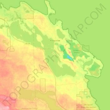
Nombre: Mapa topográfico Presque Isle Township, altitud, relieve.
Altitud media: 187 m
Altitud mínima: 128 m
Altitud máxima: 248 m
Otros mapas topográficos
Haga clic en un mapa para ver su topografía, su altitud y su relieve.
North Allis Township
United States > Michigan > Presque Isle County
North Allis Township, Presque Isle County, Michigan, United States
Altitud media: 224 m
Sinkhole
United States > Michigan > Presque Isle County > Presque Isle Township
Sinkhole, Presque Isle Township, Presque Isle County, Michigan, United States
Altitud media: 192 m
Ocqueoc
United States > Michigan > Presque Isle County
Ocqueoc, Ocqueoc Township, Presque Isle County, Michigan, United States
Altitud media: 226 m
Case Township
United States > Michigan > Presque Isle County
Case Township, Presque Isle County, Michigan, United States
Altitud media: 253 m
Hessler Lake
United States > Michigan > Presque Isle County
Hessler Lake, Case Township, Presque Isle County, Michigan, United States
Altitud media: 260 m
Posen
United States > Michigan > Presque Isle County
Posen, Posen Township, Presque Isle County, Michigan, United States
Altitud media: 238 m
Grand Island
United States > Michigan > Presque Isle County > Presque Isle Township
Grand Island, Presque Isle Township, Presque Isle County, Michigan, United States
Altitud media: 182 m
Manitou Beach
United States > Michigan > Presque Isle County > Manitou Beach
Manitou Beach, Rogers Township, Presque Isle County, Michigan, United States
Altitud media: 184 m
Rogers City
United States > Michigan > Presque Isle County
Rogers City, Presque Isle County, Michigan, 49779, United States
Altitud media: 188 m