
Mapa topográfico Ellwood
Mapa interactivo
Haga clic en el mapa para ver la altitud.
Acerca de este mapa
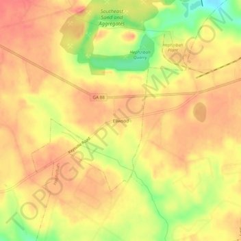
Nombre: Mapa topográfico Ellwood, altitud, relieve.
Lugar: Ellwood, Augusta, Richmond County, Georgia, United States (33.28431 -82.14929 33.32431 -82.10929)
Altitud media: 119 m
Altitud mínima: 73 m
Altitud máxima: 142 m
Otros mapas topográficos
Haga clic en un mapa para ver su topografía, su altitud y su relieve.
Augusta Canal
United States > Georgia > Richmond County > Augusta
Augusta Canal, Augusta, Richmond County, Georgia, United States
Altitud media: 80 m
Dorchester
United States > Georgia > Richmond County > Augusta
Dorchester, Augusta, Richmond County, Georgia, 30909, United States
Altitud media: 90 m
Forest Acres
United States > Georgia > Richmond County > Augusta
Forest Acres, Augusta, Richmond County, Georgia, 30904, United States
Altitud media: 67 m
Fairvale
United States > Georgia > Richmond County > Augusta
Fairvale, Augusta, Richmond County, Georgia, 30906, United States
Altitud media: 56 m
Berckman Villas
United States > Georgia > Richmond County > Augusta > Berckman Villas
Berckman Villas, Augusta, Richmond County, Georgia, 30904, United States
Altitud media: 87 m
Fort Gordon
United States > Georgia > Richmond County > Augusta > Fort Gordon
Fort Gordon, Augusta, Richmond County, Georgia, 30905, United States
Altitud media: 136 m