
Mapa topográfico Grant County
Mapa interactivo
Haga clic en el mapa para ver la altitud.
Acerca de este mapa
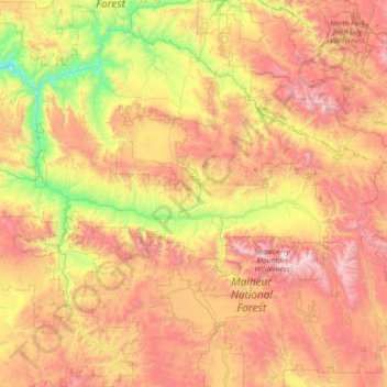
Nombre: Mapa topográfico Grant County, altitud, relieve.
Lugar: Grant County, Oregon, United States (43.95742 -119.67199 44.99817 -118.22349)
Altitud media: 1.425 m
Altitud mínima: 537 m
Altitud máxima: 2.660 m
The elevation of the county varies from 1,820 on the John Day River near Kimberly, to 9,038 feet (2,755 m) at the summit of Strawberry Mountain. The terrain of the county varies from grassland steppes and rangelands in relatively open or rolling hills and valleys, to steep, rugged, rocky high-alpine landscapes. Between these, the county contains heavily timbered land, many rolling hills, canyons and mountainous terrain. Portions of the county are technically high desert, dominated by sagebrush and sparse grasses.
Otros mapas topográficos
Haga clic en un mapa para ver su topografía, su altitud y su relieve.
Sandy
United States > Oregon > Clackamas County
Sandy, Clackamas County, Oregon, 97055, United States
Altitud media: 247 m
Portland
United States > Oregon > Multnomah County
Portland, Multnomah County, Oregon, United States
Altitud media: 77 m
Oregon City
United States > Oregon > Clackamas County
Oregon City, Clackamas County, Oregon, 97045, United States
Altitud media: 99 m
Bend
United States > Oregon > Deschutes County
Bend, Deschutes County, Oregon, United States
Altitud media: 1.121 m
Ashland
United States > Oregon > Jackson County
Ashland, Jackson County, Oregon, United States
Altitud media: 774 m
Eugene
United States > Oregon > Lane County
Eugene, Lane County, Oregon, United States
Altitud media: 163 m
Hillsboro
United States > Oregon > Washington County
Hillsboro, Washington County, Oregon, United States
Altitud media: 53 m
Mount Mazama
United States > Oregon > Klamath County
Mount Mazama, Klamath County, Oregon, United States
Altitud media: 1.880 m