
Mapa topográfico Dedham
Mapa interactivo
Haga clic en el mapa para ver la altitud.
Acerca de este mapa
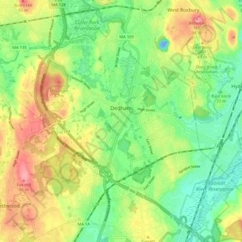
Nombre: Mapa topográfico Dedham, altitud, relieve.
Lugar: Dedham, Norfolk County, Massachusetts, United States (42.20922 -71.23172 42.28046 -71.13075)
Altitud media: 43 m
Altitud mínima: -24 m
Altitud máxima: 100 m
The first man-made canal in North America, Mother Brook, was created in Dedham in 1639. It linked the Charles River to the Neponset River. Although both are slow-moving rivers, they are at different elevations. The difference in elevation made the canal's current swift enough to power several local mills.
Otros mapas topográficos
Haga clic en un mapa para ver su topografía, su altitud y su relieve.
Ashcroft
United States > Massachusetts > Norfolk County > Dedham > Ashcroft
Ashcroft, Dedham, Norfolk County, Massachusetts, 02026-5036, United States
Altitud media: 30 m