
Mapa topográfico Barbourville
Mapa interactivo
Haga clic en el mapa para ver la altitud.
Acerca de este mapa
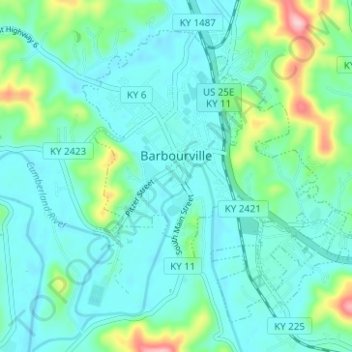
Nombre: Mapa topográfico Barbourville, altitud, relieve.
Lugar: Barbourville, Knox County, Kentucky, 40906, United States (36.84275 -83.90541 36.88420 -83.84297)
Altitud media: 323 m
Altitud mínima: 286 m
Altitud máxima: 476 m
Otros mapas topográficos
Haga clic en un mapa para ver su topografía, su altitud y su relieve.
Walker
United States > Kentucky > Knox County
Walker, Knox County, Kentucky, 40997, United States
Altitud media: 403 m
Hinkle
United States > Kentucky > Knox County
Hinkle, Knox County, Kentucky, 40915, United States
Altitud media: 368 m
Flat Lick
United States > Kentucky > Knox County
Flat Lick, Knox County, Kentucky, 40935, United States
Altitud media: 349 m
Big Rock
United States > Kentucky > Knox County
Big Rock, Knox County, Kentucky, 40923, United States
Altitud media: 355 m
Baughman
United States > Kentucky > Knox County > Baughman
Baughman, Knox County, Kentucky, 40915, United States
Altitud media: 360 m