
Mapa topográfico Orania
Mapa interactivo
Haga clic en el mapa para ver la altitud.
Acerca de este mapa
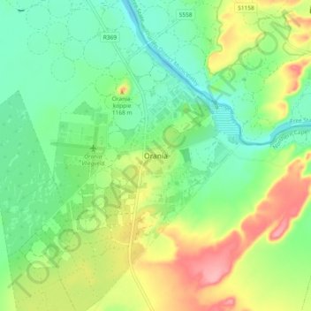
Nombre: Mapa topográfico Orania, altitud, relieve.
Altitud media: 1.115 m
Altitud mínima: 1.074 m
Altitud máxima: 1.187 m
Otros mapas topográficos
Haga clic en un mapa para ver su topografía, su altitud y su relieve.
Hopetown
South Africa > Northern Cape > Pixley ka Seme District Municipality > Thembelihle Local Municipality
Hopetown, Thembelihle Local Municipality, Pixley ka Seme District Municipality, Northern Cape, South Africa
Altitud media: 1.101 m
Strydenburg
South Africa > Northern Cape > Pixley ka Seme District Municipality > Thembelihle Local Municipality
Strydenburg, Thembelihle Local Municipality, Pixley ka Seme District Municipality, Northern Cape, 8765, South Africa
Altitud media: 1.097 m