
Mapa topográfico Waynesville
Mapa interactivo
Haga clic en el mapa para ver la altitud.
Acerca de este mapa
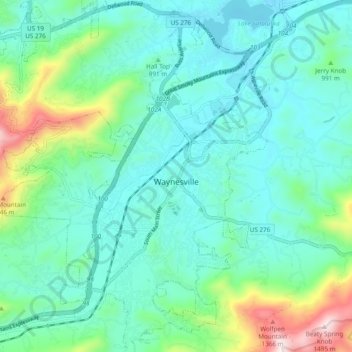
Nombre: Mapa topográfico Waynesville, altitud, relieve.
Altitud media: 921 m
Altitud mínima: 772 m
Altitud máxima: 1.484 m
Most of the town of Waynesville lies between 2,600 and 3,000 feet (790 and 910 m) above sea level, in a valley among 5,000-to-6,410-foot (1,520 to 1,950 m) mountain peaks. With the high Great Balsam Mountains to the west-southwest, and the Plott Balsams to the west-northwest, a handful of peaks over 6000' in elevation are clearly visible from town. A USGS survey marker at the old Haywood County Courthouse in downtown Waynesville lists the elevation as 2,752 feet (839 m) above sea level.
Otros mapas topográficos
Haga clic en un mapa para ver su topografía, su altitud y su relieve.
Fibreville
United States > North Carolina > Haywood County > Canton
Fibreville, Canton, Haywood County, North Carolina, 28716, United States
Altitud media: 829 m