
Gracias por apoyar a este sitio ❤️
Haz una donación
Haz una donación
Mapa topográfico La Glace
Haga clic en el mapa para ver la altitud.
Gracias por apoyar a este sitio ❤️
Haz una donación
Haz una donación
La Glace
La Glace is a hamlet in northern Alberta, Canada within the County of Grande Prairie No. 1. It is located along Highway 59 between Sexsmith and Valhalla Centre and has an elevation of 735 metres (2,411 ft).
Gracias por apoyar a este sitio ❤️
Haz una donación
Haz una donación
Acerca de este mapa
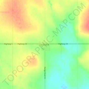
Nombre: Mapa topográfico La Glace, altitud, relieve.
Altitud media: 738 m
Altitud mínima: 713 m
Altitud máxima: 764 m
Gracias por apoyar a este sitio ❤️
Haz una donación
Haz una donación