
Mapa topográfico Highgate Springs
Mapa interactivo
Haga clic en el mapa para ver la altitud.
Acerca de este mapa
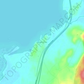
Nombre: Mapa topográfico Highgate Springs, altitud, relieve.
Altitud media: 38 m
Altitud mínima: 26 m
Altitud máxima: 106 m
Otros mapas topográficos
Haga clic en un mapa para ver su topografía, su altitud y su relieve.
Highgate Center
United States > Vermont > Franklin County > Highgate
Highgate Center, Highgate, Franklin County, Vermont, 05459, United States
Altitud media: 82 m