
Mapa topográfico Mount Rushmore
Mapa interactivo
Haga clic en el mapa para ver la altitud.
Acerca de este mapa
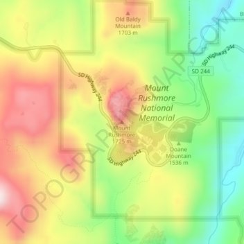
Nombre: Mapa topográfico Mount Rushmore, altitud, relieve.
Altitud media: 1.562 m
Altitud mínima: 1.367 m
Altitud máxima: 1.766 m
Mount Rushmore National Memorial is centered on a colossal sculpture carved into the granite face of Mount Rushmore (Lakota: Tȟuŋkášila Šákpe, or Six Grandfathers) in the Black Hills near Keystone, South Dakota. Sculptor Gutzon Borglum created the sculpture's design and oversaw the project's execution from 1927 to 1941 with the help of his son, Lincoln Borglum. The sculpture features the 60-foot (18 m) heads of Presidents George Washington (1732–1799), Thomas Jefferson (1743–1826), Theodore Roosevelt (1858–1919) and Abraham Lincoln (1809–1865), as recommended by Borglum. The four presidents were chosen to represent the nation's birth, growth, development and preservation, respectively. The memorial park covers 1,278 acres (2.00 sq mi; 5.17 km2) and the actual mountain has an elevation of 5,725 feet (1,745 m) above sea level.
Otros mapas topográficos
Haga clic en un mapa para ver su topografía, su altitud y su relieve.
Black Hills
United States > South Dakota > Pennington County
Black Hills, Pennington County, South Dakota, United States
Altitud media: 1.894 m
Moon
United States > South Dakota > Pennington County
Moon, Pennington County, South Dakota, United States
Altitud media: 1.938 m
Rapid Creek
United States > South Dakota > Pennington County
Rapid Creek, Pennington County, South Dakota, United States
Altitud media: 1.689 m
Rapid City
United States > South Dakota > Pennington County
Rapid City, Pennington County, South Dakota, United States
Altitud media: 1.068 m
Mount Rushmore National Memorial
United States > South Dakota > Pennington County
Mount Rushmore National Memorial, Pennington County, South Dakota, United States
Altitud media: 1.528 m
Rapid Valley
United States > South Dakota > Pennington County > Rapid Valley
Rapid Valley, Pennington County, South Dakota, 57703-6649, United States
Altitud media: 977 m