
Mapa topográfico Barren River
Mapa interactivo
Haga clic en el mapa para ver la altitud.
Acerca de este mapa
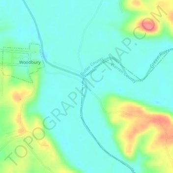
Nombre: Mapa topográfico Barren River, altitud, relieve.
Lugar: Barren River, Warren County, Kentucky, 42288, USA (37.17786 -86.62407 37.18124 -86.62278)
Altitud media: 139 m
Altitud mínima: 117 m
Altitud máxima: 195 m
Otros mapas topográficos
Haga clic en un mapa para ver su topografía, su altitud y su relieve.
Sugar Loaf Mountain
Sugar Loaf Mountain, Fleming County, Kentucky, USA
Altitud media: 259 m
Spring Hill
USA > Kentucky > Spring Hill
Spring Hill, Hickman County, Kentucky, USA
Altitud media: 121 m
Gardenside
USA > Kentucky > Gardenside
Gardenside, Fayette County, Kentucky, 40504, USA
Altitud media: 293 m
Little Georgetown
USA > Kentucky > Little Georgetown
Little Georgetown, Fayette County, Kentucky, 40513, USA
Altitud media: 285 m
Mount Washington
USA > Kentucky > Mount Washington
Mount Washington, Bullitt County, Kentucky, 40047, USA
Altitud media: 184 m
The Meadow
USA > Kentucky > The Meadow
The Meadow, Jefferson County, Kentucky, 40242, USA
Altitud media: 200 m