
Mapa topográfico Blairsville
Mapa interactivo
Haga clic en el mapa para ver la altitud.
Acerca de este mapa
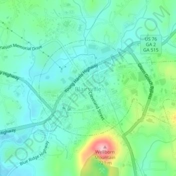
Nombre: Mapa topográfico Blairsville, altitud, relieve.
Lugar: Blairsville, Union County, Georgia, United States (34.86877 -83.96754 34.88341 -83.93990)
Altitud media: 587 m
Altitud mínima: 542 m
Altitud máxima: 726 m
Blairsville has a humid subtropical climate, yet due to its elevation of 1,883 feet (574 m), typically records far lower temperatures at night than what is encountered in much of the Southeastern U.S., and has slightly higher precipitation totals (56 inches or 1,420 millimetres annually) than most locations in the state; the average diurnal temperature variation exceeds 25 °F (14 °C) in each of the spring and autumn months. Snow usually occurs several times every year. The average annual snowfall is 4 inches. The monthly daily mean temperature ranges from 36.8 °F (2.7 °C) in January to 73.3 °F (22.9 °C) in July. There are 7.6 days of 90 °F (32 °C) highs and 4.6 days where the high fails to rise above freezing annually.
Otros mapas topográficos
Haga clic en un mapa para ver su topografía, su altitud y su relieve.
Spile
United States > Georgia > Union County
Spile, Union County, Georgia, United States
Altitud media: 646 m
Suches
United States > Georgia > Union County
Suches, Union County, Georgia, United States
Altitud media: 871 m
Vogel State Park
United States > Georgia > Union County
Vogel State Park, Union County, Georgia, United States
Altitud media: 838 m
Hawk Mountain
United States > Georgia > Union County
Hawk Mountain, Union County, Georgia, United States
Altitud media: 912 m
Bethlehem
United States > Georgia > Union County
Bethlehem, Union County, Georgia, United States
Altitud media: 582 m
Fort Mountain
United States > Georgia > Union County
Fort Mountain, Union County, Georgia, United States
Altitud media: 679 m
Blue Rock
United States > Georgia > Union County
Blue Rock, Union County, Georgia, United States
Altitud media: 780 m