
Mapa topográfico Feohanagh
Mapa interactivo
Haga clic en el mapa para ver la altitud.
Acerca de este mapa
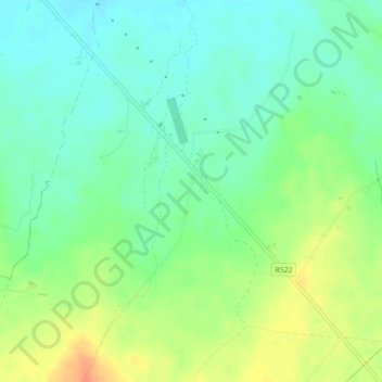
Nombre: Mapa topográfico Feohanagh, altitud, relieve.
Altitud media: 72 m
Altitud mínima: 56 m
Altitud máxima: 96 m
Otros mapas topográficos
Haga clic en un mapa para ver su topografía, su altitud y su relieve.
Knockaderry
Ireland > The Municipal District of Newcastle West
Knockaderry, The Municipal District of Newcastle West, County Limerick, Munster, Ireland
Altitud media: 64 m
Tarbet Bay
Ireland > The Municipal District of Newcastle West
Tarbet Bay, Glin, The Municipal District of Newcastle West, County Limerick, Munster, Ireland
Altitud media: 9 m
Feohanagh
Ireland > The Municipal District of Newcastle West
Feohanagh, Broadford, The Municipal District of Newcastle West, County Limerick, Munster, Ireland
Altitud media: 71 m
Ardagh
Ireland > The Municipal District of Newcastle West
Ardagh, The Municipal District of Newcastle West, County Limerick, Munster, Ireland
Altitud media: 106 m
Knockaunnagun
Ireland > The Municipal District of Newcastle West
Knockaunnagun, Glensharrold, The Municipal District of Newcastle West, County Limerick, Munster, Ireland
Altitud media: 202 m
Ballintober
Ireland > The Municipal District of Newcastle West
Ballintober, The Municipal District of Newcastle West, County Limerick, Munster, Ireland
Altitud media: 122 m