
Mapa topográfico Arlington
Mapa interactivo
Haga clic en el mapa para ver la altitud.
Acerca de este mapa
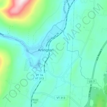
Nombre: Mapa topográfico Arlington, altitud, relieve.
Lugar: Arlington, Bennington County, Vermont, United States (43.04866 -73.16635 43.09792 -73.11899)
Altitud media: 282 m
Altitud mínima: 175 m
Altitud máxima: 768 m
Arlington lies in the Valley of Vermont between the Taconic Range to the west and the Green Mountains to the east, with most of Arlington's land mass lying in the Taconic Range. Five prominent peaks are located within the town: Grass Mountain, Spruce Peak, The Ball (also locally referred to as West Mountain), Red Mountain, and Big Spruce Mountain. The highest peak is Grass Mountain at elevation 3,109 ft (948 m).