
Haz una donación
Mapa topográfico Cernache do Bonjardim
Haga clic en el mapa para ver la altitud.
Haz una donación
Acerca de este mapa
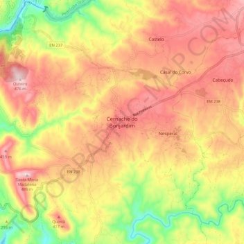
Nombre: Mapa topográfico Cernache do Bonjardim, altitud, relieve.
Altitud media: 322 m
Altitud mínima: 118 m
Altitud máxima: 474 m
Haz una donación
Otros mapas topográficos
Haga clic en un mapa para ver su topografía, su altitud y su relieve.
Aldeia do Bispo, Águas e Aldeia de João Pires
Portugal > Castelo Branco > Penamacor
Altitud media: 429 m
Haz una donación
Haz una donación
Vila de Rei
At the small town of Vila de Rei, it is worth admiring the 18th century Parish Church and the Miserichord Chapel. A natural curiosity of Vila de Rei is the Penedo Furado (pierced boulder), which has been adapted to shelter two belvederes, set on a rocky platform surrounded by woods and small water-falls. The…
Altitud media: 281 m
Haz una donación
Haz una donación
Covilhã
The cold increases according to altitude, varying from higher temperatures in the lower parts of the municipality, to colder temperatures with frequent and sometimes abundant snowfalls during the cold months in the higher areas, such as Penhas da Saúde, above 1,500 meters of altitude, 9 km away from the…
Altitud media: 710 m
Haz una donación
Vila de Rei
At the small town of Vila de Rei, it is worth admiring the 18th century Parish Church and the Miserichord Chapel. A natural curiosity of Vila de Rei is the Penedo Furado (pierced boulder), which has been adapted to shelter two belvederes, set on a rocky platform surrounded by woods and small water-falls. The…
Altitud media: 281 m
Haz una donación
Haz una donación
Haz una donación
Idanha-a-Nova
Idanha-a-Nova has a Mediterranean climate (Köppen: Csa) with cool to mild, rainy winters and hot, dry summers. The town is located at roughly 380 m (1,250 ft) altitude. Places at lower elevations (e.g. Ladoeiro, shown below) can get even hotter in the summer, with average daily temperatures rounding 33–34…
Altitud media: 321 m
Haz una donación
Haz una donación
Haz una donación