
Mapa topográfico Las Vegas
Mapa interactivo
Haga clic en el mapa para ver la altitud.
Acerca de este mapa
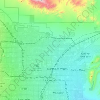
Nombre: Mapa topográfico Las Vegas, altitud, relieve.
Lugar: Las Vegas, Clark County, Nevada, United States (36.12955 -115.42428 36.38084 -115.06207)
Altitud media: 756 m
Altitud mínima: 505 m
Altitud máxima: 2.100 m
The peaks surrounding Las Vegas reach elevations of over 10,000 feet (3,000 m) and act as barriers to the strong flow of moisture from the surrounding area. The elevation is approximately 2,030 ft (620 m) above sea level. According to the United States Census Bureau, the city has an area of 135.86 sq mi (351.9 km2), of which 135.81 sq mi (351.7 km2) is land and 0.05 sq mi (0.13 km2) (0.03%) is water.
Otros mapas topográficos
Haga clic en un mapa para ver su topografía, su altitud y su relieve.
Nellis Air Force Base
United States > Nevada > Clark County
Nellis Air Force Base, Clark County, Nevada, 89115, United States
Altitud media: 576 m
Henderson
United States > Nevada > Clark County
Henderson, Clark County, Nevada, United States
Altitud media: 691 m
Whitney
United States > Nevada > Clark County
Whitney, Clark County, Nevada, 89112, United States
Altitud media: 524 m