
Mapa topográfico Henderson
Mapa interactivo
Haga clic en el mapa para ver la altitud.
Acerca de este mapa
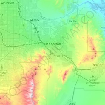
Nombre: Mapa topográfico Henderson, altitud, relieve.
Lugar: Henderson, Clark County, Nevada, United States (35.89182 -115.21936 36.12498 -114.90220)
Altitud media: 691 m
Altitud mínima: 365 m
Altitud máxima: 1.538 m
Henderson is a city in Clark County, Nevada, United States, about 16 miles (26 km) southeast of downtown Las Vegas. It is the 2nd most populous city in Nevada, after Las Vegas, with an estimated population of 320,189 in 2019. The city is part of the Las Vegas Valley. Henderson occupies the southeastern end of the valley, at an elevation of 1,864 feet (568 m).
Otros mapas topográficos
Haga clic en un mapa para ver su topografía, su altitud y su relieve.
Nellis Air Force Base
United States > Nevada > Clark County
Nellis Air Force Base, Clark County, Nevada, 89115, United States
Altitud media: 576 m
Las Vegas
United States > Nevada > Clark County
Las Vegas, Clark County, Nevada, United States
Altitud media: 756 m
Whitney
United States > Nevada > Clark County
Whitney, Clark County, Nevada, 89112, United States
Altitud media: 524 m