
Haz una donación
Mapa topográfico Bute Inlet
Haga clic en el mapa para ver la altitud.
Haz una donación
Bute Inlet
The Bute Inlet route was later considered for the mainline of the Canadian Pacific Railway (CPR), which would have seen extensive blasting down the west shore of the inlet and a series of bridges to reach Vancouver Island near Campbell River via Seymour Narrows. This route was passed over in favour of the Fraser Canyon route to a new port-city at Burrard Inlet, which was to become the city of Port Moody. The residual political impact of the Chilcotin War was one factor dissuading the CPR from using Bute Inlet; the other was the severe grades required in the canyon of the Homathko River in order to reach the elevation of the Chilcotin Plateau on the inland side of the Coast Range, as well as the cost of blasting along the inlet and the deep water bridges needed below it.
Haz una donación
Acerca de este mapa
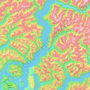
Nombre: Mapa topográfico Bute Inlet, altitud, relieve.
Altitud media: 921 m
Altitud mínima: 0 m
Altitud máxima: 2.636 m
Haz una donación
Otros mapas topográficos
Haga clic en un mapa para ver su topografía, su altitud y su relieve.
Quathiaski Cove
Canada > British Columbia > Strathcona Regional District > Area B (Discovery Islands/Mainland Inlets)
Altitud media: 40 m
Broken Islands
Canada > British Columbia > Strathcona Regional District > Area B (Discovery Islands/Mainland Inlets)
Altitud media: 10 m
Mount Bute
Canada > British Columbia > Strathcona Regional District > Area B (Discovery Islands/Mainland Inlets)
Altitud media: 1.993 m
Mount Hayes
Canada > British Columbia > Strathcona Regional District > Area B (Discovery Islands/Mainland Inlets)
Altitud media: 1.101 m
Haz una donación
Heriot Bay
Canada > British Columbia > Strathcona Regional District > Area B (Discovery Islands/Mainland Inlets)
Altitud media: 38 m
Mount Raleigh
Canada > British Columbia > Strathcona Regional District > Area B (Discovery Islands/Mainland Inlets)
Mount Raleigh, elevation 3,132 m (10,276 ft), is one of the principal summits of the Pacific Ranges of the Coast Mountains of southern British Columbia in Canada. It is located just southeast of the confluence of the Southgate and Bishop Rivers, northeast of the head of Bute Inlet, and is the highest summit…
Altitud media: 2.414 m
Discovery Mountain
Canada > British Columbia > Strathcona Regional District > Area B (Discovery Islands/Mainland Inlets)
Altitud media: 361 m
Ripple Rock
Canada > British Columbia > Strathcona Regional District > Area B (Discovery Islands/Mainland Inlets)
Altitud media: 40 m
Haz una donación
Pembroke Range
Canada > British Columbia > Strathcona Regional District > Area B (Discovery Islands/Mainland Inlets)
Altitud media: 633 m