
Haz una donación
Mapa topográfico Pembroke Range
Haga clic en el mapa para ver la altitud.
Haz una donación
Acerca de este mapa
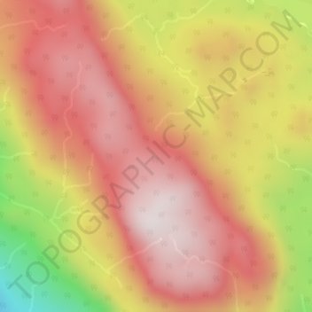
Nombre: Mapa topográfico Pembroke Range, altitud, relieve.
Altitud media: 633 m
Altitud mínima: 147 m
Altitud máxima: 912 m
Haz una donación
Otros mapas topográficos
Haga clic en un mapa para ver su topografía, su altitud y su relieve.
Quadra Island
Canada > British Columbia > Strathcona Regional District > Area B (Discovery Islands/Mainland Inlets)
Altitud media: 128 m
Sonora Island
Canada > British Columbia > Strathcona Regional District > Area B (Discovery Islands/Mainland Inlets)
Altitud media: 186 m
Bute Inlet
Canada > British Columbia > Strathcona Regional District > Area B (Discovery Islands/Mainland Inlets)
The Bute Inlet route was later considered for the mainline of the Canadian Pacific Railway (CPR), which would have seen extensive blasting down the west shore of the inlet and a series of bridges to reach Vancouver Island near Campbell River via Seymour Narrows. This route was passed over in favour of the…
Altitud media: 921 m
Whiterock Passage
Canada > British Columbia > Strathcona Regional District > Area B (Discovery Islands/Mainland Inlets)
Altitud media: 174 m
Haz una donación
East Redonda Island
Canada > British Columbia > Strathcona Regional District > Area B (Discovery Islands/Mainland Inlets)
Altitud media: 327 m
Broken Islands
Canada > British Columbia > Strathcona Regional District > Area B (Discovery Islands/Mainland Inlets)
Altitud media: 10 m
Hardwicke Island
Canada > British Columbia > Strathcona Regional District > Area B (Discovery Islands/Mainland Inlets)
Altitud media: 132 m
Heriot Bay
Canada > British Columbia > Strathcona Regional District > Area B (Discovery Islands/Mainland Inlets) > Heriot Bay
Altitud media: 44 m
Haz una donación
Yorke Island
Canada > British Columbia > Strathcona Regional District > Area B (Discovery Islands/Mainland Inlets)
Altitud media: 9 m
Jackson Bay
Canada > British Columbia > Strathcona Regional District > Area B (Discovery Islands/Mainland Inlets)
Altitud media: 118 m
Quadra Island
Canada > British Columbia > Strathcona Regional District > Area B (Discovery Islands/Mainland Inlets)
Altitud media: 128 m