
Mapa topográfico Labastida/Bastida
Mapa interactivo
Haga clic en el mapa para ver la altitud.
Acerca de este mapa
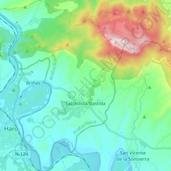
Nombre: Mapa topográfico Labastida/Bastida, altitud, relieve.
Altitud media: 611 m
Altitud mínima: 423 m
Altitud máxima: 1.252 m
The town is at 529m altitude, and is positioned between the River Ebro and the Sierra de Toloño mountain range.
Otros mapas topográficos
Haga clic en un mapa para ver su topografía, su altitud y su relieve.
Salinillas de Buradón/Gatzaga Buradon
Spain > Autonomous Community of the Basque Country > Arabako Errioxa/Rioja Alavesa > Labastida/Bastida
Salinillas de Buradón/Gatzaga Buradon, Labastida/Bastida, Arabako Errioxa/Rioja Alavesa, Álava, Autonomous Community of the Basque Country, Spain
Altitud media: 599 m
Laguardia
Spain > Autonomous Community of the Basque Country > Arabako Errioxa/Rioja Alavesa
Laguardia, Arabako Errioxa/Rioja Alavesa, Álava, Autonomous Community of the Basque Country, Spain
Altitud media: 592 m
Oyón/Oion
Spain > Autonomous Community of the Basque Country > Arabako Errioxa/Rioja Alavesa
Oyón/Oion, Arabako Errioxa/Rioja Alavesa, Álava, Autonomous Community of the Basque Country, 01320, Spain
Altitud media: 572 m