
Mapa topográfico Laguardia
Mapa interactivo
Haga clic en el mapa para ver la altitud.
Acerca de este mapa
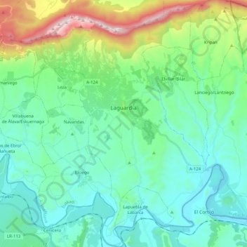
Nombre: Mapa topográfico Laguardia, altitud, relieve.
Altitud media: 592 m
Altitud mínima: 369 m
Altitud máxima: 1.385 m
Otros mapas topográficos
Haga clic en un mapa para ver su topografía, su altitud y su relieve.
Labastida/Bastida
Spain > Autonomous Community of the Basque Country > Arabako Errioxa/Rioja Alavesa
Labastida/Bastida, Arabako Errioxa/Rioja Alavesa, Álava, Autonomous Community of the Basque Country, 01330, Spain
Altitud media: 611 m
Salinillas de Buradón/Gatzaga Buradon
Spain > Autonomous Community of the Basque Country > Arabako Errioxa/Rioja Alavesa > Labastida/Bastida
Salinillas de Buradón/Gatzaga Buradon, Labastida/Bastida, Arabako Errioxa/Rioja Alavesa, Álava, Autonomous Community of the Basque Country, Spain
Altitud media: 599 m
Oyón/Oion
Spain > Autonomous Community of the Basque Country > Arabako Errioxa/Rioja Alavesa
Oyón/Oion, Arabako Errioxa/Rioja Alavesa, Álava, Autonomous Community of the Basque Country, 01320, Spain
Altitud media: 572 m