
Mapa topográfico Saint-Léger
Mapa interactivo
Haga clic en el mapa para ver la altitud.
Acerca de este mapa
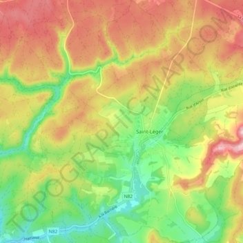
Nombre: Mapa topográfico Saint-Léger, altitud, relieve.
Lugar: Saint-Léger, Virton, Luxembourg, Wallonie, Belgique (49.58651 5.61552 49.64516 5.68776)
Altitud media: 305 m
Altitud mínima: 225 m
Altitud máxima: 386 m
Otros mapas topográficos
Haga clic en un mapa para ver su topografía, su altitud y su relieve.
Chatillon
Belgique > Luxembourg > Virton > Saint-Léger
Chatillon, Saint-Léger, Virton, Luxembourg, Wallonie, 6747, Belgique
Altitud media: 340 m