
Mapa topográfico Barnstable County
Mapa interactivo
Haga clic en el mapa para ver la altitud.
Acerca de este mapa
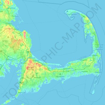
Nombre: Mapa topográfico Barnstable County, altitud, relieve.
Lugar: Barnstable County, Massachusetts, United States of America (41.48044 -70.76063 42.13365 -69.86010)
Altitud media: 7 m
Altitud mínima: -8 m
Altitud máxima: 113 m
The highest elevation in the county is 306 feet (93 m) on the summit of Pine Hill, located on Joint Base Cape Cod in Bourne. The lowest point is sea level.
Otros mapas topográficos
Haga clic en un mapa para ver su topografía, su altitud y su relieve.
North Attleborough
United States of America > Massachusetts > North Attleborough > North Attleborough
North Attleborough, Bristol County, Massachusetts, 02760, United States of America
Altitud media: 54 m
Hampshire County
United States of America > Massachusetts
Hampshire County, Massachusetts, United States of America
Altitud media: 243 m
Hampden County
United States of America > Massachusetts
Hampden County, Massachusetts, United States of America
Altitud media: 209 m
Berkshire County
United States of America > Massachusetts
Berkshire County, Massachusetts, United States of America
Altitud media: 359 m
Bristol County
United States of America > Massachusetts
Bristol County, Massachusetts, United States of America
Altitud media: 26 m