
Mapa topográfico Berkshire County
Mapa interactivo
Haga clic en el mapa para ver la altitud.
Acerca de este mapa
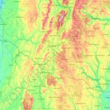
Nombre: Mapa topográfico Berkshire County, altitud, relieve.
Lugar: Berkshire County, Massachusetts, United States of America (42.03982 -73.50814 42.74585 -72.94944)
Altitud media: 359 m
Altitud mínima: 2 m
Altitud máxima: 1.061 m
Running north-south through the county are the Hoosac Range of the Berkshire Hills in the eastern part of the county and the Taconic Mountains in the western part of the county. Due to their elevation, the Berkshires attract tourists and summer residents eager to escape the heat of the lowlands.
Otros mapas topográficos
Haga clic en un mapa para ver su topografía, su altitud y su relieve.
North Attleborough
United States of America > Massachusetts > North Attleborough > North Attleborough
North Attleborough, Bristol County, Massachusetts, 02760, United States of America
Altitud media: 54 m
Hampshire County
United States of America > Massachusetts
Hampshire County, Massachusetts, United States of America
Altitud media: 243 m
Hampden County
United States of America > Massachusetts
Hampden County, Massachusetts, United States of America
Altitud media: 209 m
Bristol County
United States of America > Massachusetts
Bristol County, Massachusetts, United States of America
Altitud media: 26 m
Barnstable County
United States of America > Massachusetts
Barnstable County, Massachusetts, United States of America
Altitud media: 7 m