
Haz una donación
Mapa topográfico Madeira Island
Haga clic en el mapa para ver la altitud.
Haz una donación
Acerca de este mapa
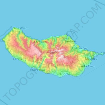
Nombre: Mapa topográfico Madeira Island, altitud, relieve.
Lugar: Madeira Island, Madeira, Portugal (32.63288 -17.26593 32.87062 -16.67914)
Altitud media: 172 m
Altitud mínima: 0 m
Altitud máxima: 1.823 m
Haz una donación
Otros mapas topográficos
Haga clic en un mapa para ver su topografía, su altitud y su relieve.
Haz una donación
Braga
The topography in the municipality is characterized by irregular valleys, interspersed by mountainous spaces, fed by rivers running in parallel with the principal rivers. In the north it is limited by the Cávado River, in the south by terrain of the Serra dos Picos to a height of 566 metres (1,857 ft) and…
Altitud media: 204 m
Haz una donación
Haz una donación
Haz una donación
São Brás de Alportel
Portugal > Faro > São Brás de Alportel > São Brás de Alportel
Altitud media: 254 m
Haz una donación
Haz una donación
Haz una donación
Mount Pico
Mount Pico (Portuguese: Montanha do Pico) is a currently dormant stratovolcano located on Pico Island, in the mid-Atlantic archipelago of the Azores. It is the highest mountain in Portugal, at 2,351 metres (7,713 ft) above sea level, and is one of the highest Atlantic mountains; it is more than twice the…
Altitud media: 1.694 m
Haz una donación
Ruivo
As the highest point in the archipelago, Pico Ruivo is primarily surrounded by high-altitude heath. The area is also marked by monumental rock formations, which often rise above the clouds, dominating the landscape. The region is home to several bird species, including the Madeira firecrest, the chaffinch, and…
Altitud media: 1.400 m
Haz una donación
Haz una donación
Haz una donación
Beloura
Portugal > Lisbon > Sintra (Santa Maria e São Miguel, São Martinho e São Pedro de Penaferrim)
Altitud media: 182 m
Haz una donación
Haz una donación
Algarve
The Algarve is located in the southernmost area of continental Portugal and the southwesternmost area of the Iberian Peninsula and mainland Europe, covering an area of 4,997 km2 (1,929 sq mi). It borders to the north with the Alentejo region (Alentejo Litoral and Baixo Alentejo), to the south and west with the…
Altitud media: 72 m
Haz una donación
Monte Gordo
Portugal > Castelo Branco > Castelo Branco > Santo André das Tojeiras
Altitud media: 285 m
Haz una donación
Haz una donación
Haz una donación
Haz una donación
Sintra
Portugal > Lisbon > Sintra (Santa Maria e São Miguel, São Martinho e São Pedro de Penaferrim)
The São João platform, along the northern flank of the Sintra Mountains, has altitudes between 100 metres (110 yd) and 150 metres (160 yd), while the southern part of the mountains, the Cascais platform, is lower: sloping from 150 metres (160 yd) to the sea, terminating along the coast, around 30 metres (33…
Altitud media: 189 m
Haz una donación
Haz una donación
Mount Pico
Mount Pico (Portuguese: Montanha do Pico) is a currently dormant stratovolcano located on Pico Island, in the mid-Atlantic archipelago of the Azores. It is the highest mountain in Portugal, at 2,351 metres (7,713 ft) above sea level, and is one of the highest Atlantic mountains; it is more than twice the…
Altitud media: 1.694 m
Haz una donación
Cidadelha de Jales
Portugal > Vila Real > Vila Pouca de Aguiar > Alfarela de Jales
Altitud media: 783 m
Haz una donación
Haz una donación
Haz una donación
Haz una donación