
Mapa topográfico Redhouse
Mapa interactivo
Haga clic en el mapa para ver la altitud.
Acerca de este mapa
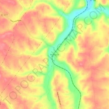
Nombre: Mapa topográfico Redhouse, altitud, relieve.
Lugar: Redhouse, Madison County, Kentucky, United States (37.81230 -84.29215 37.85230 -84.25215)
Altitud media: 248 m
Altitud mínima: 192 m
Altitud máxima: 279 m
Otros mapas topográficos
Haga clic en un mapa para ver su topografía, su altitud y su relieve.
Berea
United States > Kentucky > Madison County
Berea, Madison County, Kentucky, United States
Altitud media: 300 m
Newby
United States > Kentucky > Madison County
Newby, Madison County, Kentucky, United States
Altitud media: 272 m
Welch Mountain
United States > Kentucky > Madison County
Welch Mountain, Madison County, Kentucky, 40404, United States
Altitud media: 315 m
Fort Boonesborough State Park
United States > Kentucky > Madison County > Boonesborough
Fort Boonesborough State Park, Boonesborough, Madison County, Kentucky, United States
Altitud media: 236 m
Richmond
United States > Kentucky > Madison County
Richmond, Madison County, Kentucky, 40475, United States
Altitud media: 281 m
Berea
United States > Kentucky > Madison County > Berea > Berea
Berea, Madison County, Kentucky, 40404, United States
Altitud media: 314 m
Richmond
United States > Kentucky > Madison County > Richmond
Richmond, Madison County, Kentucky, 40475, United States
Altitud media: 267 m