
Mapa topográfico Berea
Mapa interactivo
Haga clic en el mapa para ver la altitud.
Acerca de este mapa
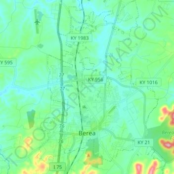
Nombre: Mapa topográfico Berea, altitud, relieve.
Lugar: Berea, Madison County, Kentucky, United States (37.54556 -84.33198 37.64341 -84.23968)
Altitud media: 300 m
Altitud mínima: 261 m
Altitud máxima: 463 m
Berea is located on the border of the Cumberland Plateau. The area has a mountainous appearance, but most outcroppings in the area have a maximum elevation of 2,500 feet or 760 metres.
Otros mapas topográficos
Haga clic en un mapa para ver su topografía, su altitud y su relieve.
Redhouse
United States > Kentucky > Madison County
Redhouse, Madison County, Kentucky, United States
Altitud media: 248 m
Newby
United States > Kentucky > Madison County
Newby, Madison County, Kentucky, United States
Altitud media: 272 m
Welch Mountain
United States > Kentucky > Madison County
Welch Mountain, Madison County, Kentucky, 40404, United States
Altitud media: 315 m
Fort Boonesborough State Park
United States > Kentucky > Madison County > Boonesborough
Fort Boonesborough State Park, Boonesborough, Madison County, Kentucky, United States
Altitud media: 236 m
Richmond
United States > Kentucky > Madison County
Richmond, Madison County, Kentucky, 40475, United States
Altitud media: 281 m
Berea
United States > Kentucky > Madison County > Berea > Berea
Berea, Madison County, Kentucky, 40404, United States
Altitud media: 314 m
Richmond
United States > Kentucky > Madison County > Richmond
Richmond, Madison County, Kentucky, 40475, United States
Altitud media: 267 m