
Haz una donación
Mapa topográfico Campbell River
Haga clic en el mapa para ver la altitud.
Haz una donación
Acerca de este mapa
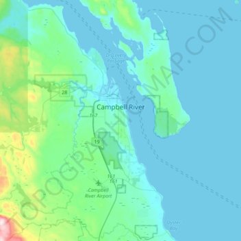
Nombre: Mapa topográfico Campbell River, altitud, relieve.
Altitud media: 70 m
Altitud mínima: -2 m
Altitud máxima: 630 m
Haz una donación
Otros mapas topográficos
Haga clic en un mapa para ver su topografía, su altitud y su relieve.
Phillips Lake
Canada > British Columbia > Strathcona Regional District > Area C (Discovery Islands/Mainland Inlets)
Altitud media: 235 m
Whaletown
Canada > British Columbia > Strathcona Regional District > Area C (Cortes Island)
Altitud media: 26 m
Whiteley Island
Canada > British Columbia > Strathcona Regional District > Area A (Kyuquot/Nootka/Sayward)
Altitud media: 16 m
Mansons Landing
Canada > British Columbia > Strathcona Regional District > Area C (Cortes Island)
Altitud media: 32 m
Haz una donación
Quathiaski Cove
Canada > British Columbia > Strathcona Regional District > Area B (Discovery Islands/Mainland Inlets)
Altitud media: 40 m
Cachalot
Canada > British Columbia > Strathcona Regional District > Area A (Kyuquot/Nootka/Sayward)
Altitud media: 386 m
Mount Hayes
Canada > British Columbia > Strathcona Regional District > Area B (Discovery Islands/Mainland Inlets)
Altitud media: 1.101 m
Heriot Bay
Canada > British Columbia > Strathcona Regional District > Area B (Discovery Islands/Mainland Inlets)
Altitud media: 38 m
Haz una donación
Oyster River
Canada > British Columbia > Strathcona Regional District > Area D (Oyster Bay/Buttle Lake) > Oyster River
Altitud media: 24 m
Elk Falls Viewing Platform
Canada > British Columbia > Strathcona Regional District > Campbell River
Altitud media: 137 m
Protection Island
Canada > British Columbia > Strathcona Regional District > Area C (Cortes Island)
Altitud media: 36 m
Ensanada Islet
Canada > British Columbia > Strathcona Regional District > Area A (Kyuquot/Nootka/Sayward)
Altitud media: 2 m
Haz una donación
Kings Peak
Canada > British Columbia > Strathcona Regional District > Area D (Oyster Bay/Buttle Lake)
Altitud media: 1.435 m
Mount Bute
Canada > British Columbia > Strathcona Regional District > Area B (Discovery Islands/Mainland Inlets)
Altitud media: 1.993 m
Upana Caves
Canada > British Columbia > Strathcona Regional District > Area A (Kyuquot/Nootka/Sayward)
Altitud media: 684 m
Wolf Mountain
Canada > British Columbia > Strathcona Regional District > Area D (Oyster Bay/Buttle Lake)
Altitud media: 1.254 m
Haz una donación
John Hart Dam
Canada > British Columbia > Strathcona Regional District > Campbell River
Altitud media: 155 m
Solander Island
Canada > British Columbia > Strathcona Regional District > Area A (Kyuquot/Nootka/Sayward)
Altitud media: 0 m
Discovery Mountain
Canada > British Columbia > Strathcona Regional District > Area B (Discovery Islands/Mainland Inlets)
Altitud media: 361 m
Mount Raleigh
Canada > British Columbia > Strathcona Regional District > Area B (Discovery Islands/Mainland Inlets)
Mount Raleigh, elevation 3,132 m (10,276 ft), is one of the principal summits of the Pacific Ranges of the Coast Mountains of southern British Columbia in Canada. It is located just southeast of the confluence of the Southgate and Bishop Rivers, northeast of the head of Bute Inlet, and is the highest summit…
Altitud media: 2.414 m
Haz una donación
Ripple Rock
Canada > British Columbia > Strathcona Regional District > Area B (Discovery Islands/Mainland Inlets)
Altitud media: 40 m
Pembroke Range
Canada > British Columbia > Strathcona Regional District > Area B (Discovery Islands/Mainland Inlets)
Altitud media: 633 m
Victor Island
Canada > British Columbia > Strathcona Regional District > Area A (Kyuquot/Nootka/Sayward)
Altitud media: 26 m
Broken Islands
Canada > British Columbia > Strathcona Regional District > Area B (Discovery Islands/Mainland Inlets)
Altitud media: 10 m
Haz una donación
Duncan Bay
Canada > British Columbia > Strathcona Regional District > Campbell River
Altitud media: 18 m
Tahsis
Canada > British Columbia > Strathcona Regional District > Tahsis > Tahsis
Altitud media: 252 m
Flower Ridge
Canada > British Columbia > Strathcona Regional District > Area D (Oyster Bay/Buttle Lake)
Altitud media: 1.095 m
Arnica Lake
Canada > British Columbia > Strathcona Regional District > Area D (Oyster Bay/Buttle Lake)
Altitud media: 1.180 m
Haz una donación