
Haz una donación
Mapa topográfico Curtis
Haga clic en el mapa para ver la altitud.
Haz una donación
Acerca de este mapa
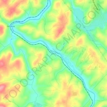
Nombre: Mapa topográfico Curtis, altitud, relieve.
Lugar: Curtis, Fannin County, Georgia, United States (34.90564 -84.35575 34.94564 -84.31575)
Altitud media: 503 m
Altitud mínima: 452 m
Altitud máxima: 569 m
Haz una donación
Otros mapas topográficos
Haga clic en un mapa para ver su topografía, su altitud y su relieve.
Blue Ridge
United States > Georgia > Fannin County
Blue Ridge, situated in Fannin County, Georgia, lies within the rugged terrain of the southern Appalachian Mountains. The town itself is at an elevation of approximately 1,762 feet (537 meters) above sea level. The surrounding landscape is characterized by a series of ridges and valleys, with elevations…
Altitud media: 535 m
McCaysville
United States > Georgia > Fannin County
McCaysville's weather is temperate due to its elevation and location in the southern Appalachians. Summers are warm with average highs in the middle 80s and lows in the lower 60s. Winters are cool with average highs in the 40s and average lows in the 20s. Rainfall is abundant with the yearly average…
Altitud media: 484 m
Haz una donación
Haz una donación