
Haz una donación
Mapa topográfico Ocoee River
Haga clic en el mapa para ver la altitud.
Haz una donación
Acerca de este mapa
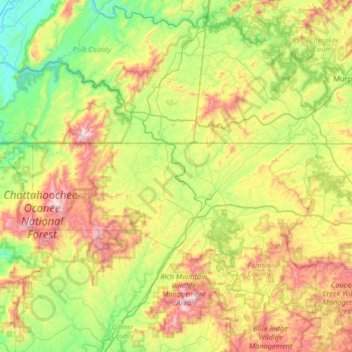
Nombre: Mapa topográfico Ocoee River, altitud, relieve.
Altitud media: 579 m
Altitud mínima: 214 m
Altitud máxima: 1.269 m
Haz una donación
Otros mapas topográficos
Haga clic en un mapa para ver su topografía, su altitud y su relieve.
Haz una donación
Springer Mountain
United States > Georgia > Fannin County
Springer Mountain is a mountain located in the Chattahoochee National Forest on the border of Fannin and Gilmer counties. Located in the Blue Ridge Mountains in northern Georgia, the mountain has an elevation of about 3,782 feet (1,153 m). Springer Mountain serves as the southern terminus for the Appalachian…
Altitud media: 941 m
Haz una donación
Haz una donación
Haz una donación
Springer Mountain
United States > Georgia > Fannin County
Springer Mountain is a mountain located in the Chattahoochee National Forest on the border of Fannin and Gilmer counties. Located in the Blue Ridge Mountains in northern Georgia, the mountain has an elevation of about 3,782 feet (1,153 m). Springer Mountain serves as the southern terminus for the Appalachian…
Altitud media: 941 m