
Mapa topográfico Ios
Mapa interactivo
Haga clic en el mapa para ver la altitud.
Acerca de este mapa
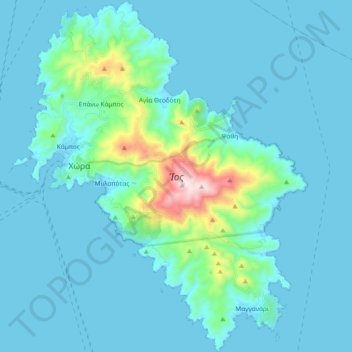
Nombre: Mapa topográfico Ios, altitud, relieve.
Lugar: Ios, Thira Regional Unit, South Aegean, Aegean, 840 01, Greece (36.64210 25.24594 36.79256 25.40308)
Altitud media: 73 m
Altitud mínima: 0 m
Altitud máxima: 717 m
The highest elevation (723 m, 2372 ft) is the Kastro (Greek: Κάστρο) peak also called Pyrgos (Greek: Πύργος), located in the center of the island, while around the Kastro are the next three Highest peaks: Xylodema (Greek: Ξυλόδεμα) (660 m, 2165 ft), Kostiza (Greek: Κοστίζα) (586 m, 1923 ft) and Prophetis Elias (Greek: Προφήτης Ηλίας) (490 m, 951 ft).
Otros mapas topográficos
Haga clic en un mapa para ver su topografía, su altitud y su relieve.
Santorini
Greece > Aegean > Thira Regional Unit > Thira Municipal Unit
Santorini, Thira Municipal Unit, Municipality of Thira, Thira Regional Unit, South Aegean, Aegean, Greece
Altitud media: 30 m
Oia
Greece > Aegean > Thira Regional Unit > Ia Municipal Unit
Oia, Ia Municipal Unit, Municipality of Thira, Thira Regional Unit, South Aegean, Aegean, 847 02, Greece
Altitud media: 20 m
Folegandros
Greece > Aegean > Thira Regional Unit > Ano Meria
Folegandros, Ano Meria, Municipality of Folegandros, Thira Regional Unit, South Aegean, Aegean, 840 11, Greece
Altitud media: 38 m
Vothonas
Greece > Aegean > Thira Regional Unit > Thira Municipal Unit
Vothonas, Thira Municipal Unit, Municipality of Thira, Thira Regional Unit, South Aegean, Aegean, 847 00, Greece
Altitud media: 136 m
Karterados
Greece > Aegean > Thira Regional Unit > Thira Municipal Unit
Karterados, Thira Municipal Unit, Municipality of Thira, Thira Regional Unit, South Aegean, Aegean, 847 00, Greece
Altitud media: 99 m