
Mapa topográfico Nelson County
Mapa interactivo
Haga clic en el mapa para ver la altitud.
Acerca de este mapa
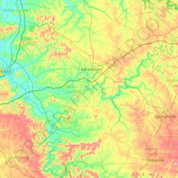
Nombre: Mapa topográfico Nelson County, altitud, relieve.
Lugar: Nelson County, Kentucky, United States (37.52277 -85.74251 37.99056 -85.15064)
Altitud media: 207 m
Altitud mínima: 127 m
Altitud máxima: 352 m
Otros mapas topográficos
Haga clic en un mapa para ver su topografía, su altitud y su relieve.
Briartown
United States > Kentucky > Washington County > Springfield
Briartown, Springfield, Washington County, Kentucky, 40069, United States
Altitud media: 233 m
Manila
United States > Kentucky > Johnson County
Manila, Johnson County, Kentucky, 41238, United States
Altitud media: 286 m
Druid Hills
United States > Kentucky > Jefferson County
Druid Hills, Jefferson County, Kentucky, United States
Altitud media: 169 m
Hazard
United States > Kentucky > Perry County
Hazard, Perry County, Kentucky, United States
Altitud media: 362 m
Ashland
United States > Kentucky > Boyd County > Ashland
Ashland, Boyd County, Kentucky, United States
Altitud media: 196 m
Normal
United States > Kentucky > Boyd County > Ashland > Normal
Normal, Ashland, Boyd County, Kentucky, 411011, United States
Altitud media: 187 m
Cliffside
United States > Kentucky > Boyd County > Ashland > Cliffside
Cliffside, Ashland, Boyd County, Kentucky, 411011, United States
Altitud media: 184 m
Louisville
United States > Kentucky > Jefferson County > Louisville
Louisville, Jefferson County, Kentucky, 40202-2923, United States
Altitud media: 180 m
Nelse
United States > Kentucky > Nelse
Nelse, Pike County, Kentucky, 41562, United States
Altitud media: 315 m