
Mapa topográfico Sunspot
Mapa interactivo
Haga clic en el mapa para ver la altitud.
Acerca de este mapa
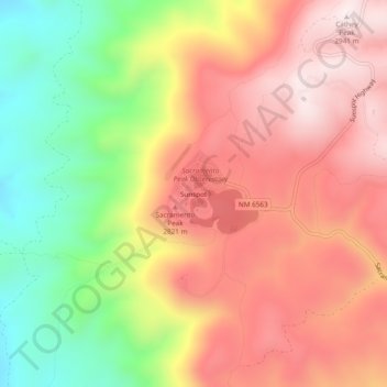
Nombre: Mapa topográfico Sunspot, altitud, relieve.
Lugar: Sunspot, Otero County, New Mexico, 88349, United States (32.76921 -105.83857 32.80921 -105.79857)
Altitud media: 2.626 m
Altitud mínima: 2.243 m
Altitud máxima: 2.932 m
The origins of Sunspot as a Solar Observatory date back to the sudden increased interest of solar physics to the US military during the Second World War. In 1940, the High Altitude Observatory (HAO) was established in 1940 in Climax, Colorado, by Walter Orr Roberts and Donald Menzel. It was associated with both Harvard College Observatory and the University of Colorado and was incorporated in 1946. At the time it was the world's highest permanent observatory for astronomy, at an elevation of over 11,000 feet, and was designed purely for studying the Sun. Roberts worked with the Bureau of Standards, "forecasting radio conditions on the basis of solar observations". Such studies of the upper atmosphere were critical for predicting conditions for radio communication, guided missiles, and supersonic aircraft and, as a result, solar observations "became essential to the war effort". Suddenly the field of solar astronomy became an appealing goal for both astronomers and the military.
Otros mapas topográficos
Haga clic en un mapa para ver su topografía, su altitud y su relieve.
Mayhill
United States > New Mexico > Otero County
Mayhill, Otero County, New Mexico, United States
Altitud media: 2.104 m
Cloudcroft
United States > New Mexico > Otero County
Cloudcroft, Otero County, New Mexico, United States
Altitud media: 2.643 m
Bent
United States > New Mexico > Otero County
Bent, Otero County, New Mexico, 88314, United States
Altitud media: 1.857 m
Chihuahuan Desert
United States > New Mexico > Otero County
Chihuahuan Desert, Otero County, New Mexico, United States
Altitud media: 1.221 m
Cloudcroft
United States > New Mexico > Otero County > Cloudcroft
Cloudcroft, Otero County, New Mexico, 88317, United States
Altitud media: 2.636 m
Tularosa
United States > New Mexico > Otero County > Tularosa
Tularosa, Otero County, New Mexico, 88352, United States
Altitud media: 1.371 m