
Mapa topográfico Campo Imperatore
Mapa interactivo
Haga clic en el mapa para ver la altitud.
Acerca de este mapa
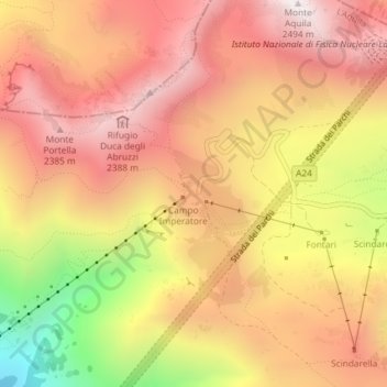
Nombre: Mapa topográfico Campo Imperatore, altitud, relieve.
Lugar: Campo Imperatore, L'Aquila, Abruzzo, Italy (42.43305 13.54872 42.45305 13.56872)
Altitud media: 2.056 m
Altitud mínima: 1.359 m
Altitud máxima: 2.476 m
The plateau's altitude ranges from 1,500 to 1,900 meters. It covers an expanse of approximately 80 km². Campo Imperatore is home to one of Italy's oldest alpine ski resorts. Located on the plateau's western edge, the resort began commercial operation in the 1920s and continues to thrive as a ski resort to this day due to its proximity to Rome (132 km). The resort's hotel became dictator Benito Mussolini's prison in August 1943 with his fall from power until he was freed by German commandos on 12 September 1943. On the eastern side of the plateau is a 4 km cross country ski trail, which is maintained by the nearby town of Castel del Monte.
Otros mapas topográficos
Haga clic en un mapa para ver su topografía, su altitud y su relieve.
Fonte Cerreto
Italy > Abruzzo > L'Aquila > L'Aquila
Fonte Cerreto, L'Aquila, Abruzzo, Italy
Altitud media: 1.329 m
Apennine Mountains
Italy > Abruzzo > L'Aquila > L'Aquila
Apennine Mountains, L'Aquila, Abruzzo, Italy
Altitud media: 1.735 m