
Mapa topográfico Hopewell
Mapa interactivo
Haga clic en el mapa para ver la altitud.
Acerca de este mapa
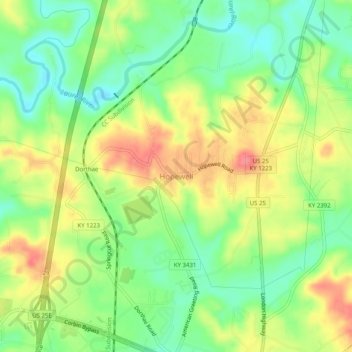
Nombre: Mapa topográfico Hopewell, altitud, relieve.
Lugar: Hopewell, Laurel County, Kentucky, 40737, United States (36.97259 -84.11188 37.01259 -84.07188)
Altitud media: 358 m
Altitud mínima: 322 m
Altitud máxima: 401 m
Otros mapas topográficos
Haga clic en un mapa para ver su topografía, su altitud y su relieve.
Lily
United States > Kentucky > Laurel County
Lily, Laurel County, Kentucky, 40740, United States
Altitud media: 350 m
Keavy
United States > Kentucky > Laurel County > Keavy
Keavy, Laurel County, Kentucky, 40737, United States
Altitud media: 363 m
Cane Creek
United States > Kentucky > Laurel County > Cane Creek
Cane Creek, Laurel County, Kentucky, United States
Altitud media: 377 m
London
United States > Kentucky > Laurel County
London, Laurel County, Kentucky, 40741, United States
Altitud media: 370 m