
Mapa topográfico London
Mapa interactivo
Haga clic en el mapa para ver la altitud.
Acerca de este mapa
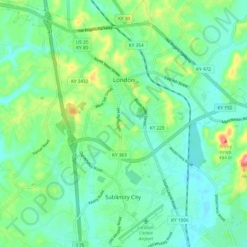
Nombre: Mapa topográfico London, altitud, relieve.
Lugar: London, Laurel County, Kentucky, 40741, United States (37.07976 -84.12626 37.15226 -84.03596)
Altitud media: 370 m
Altitud mínima: 338 m
Altitud máxima: 462 m
London is located in central Laurel County at 37°7′39″N 84°5′3″W / 37.12750°N 84.08417°W / 37.12750; -84.08417 (37.127504, -84.084181) and at an elevation of 1,240 feet (380 m).
Otros mapas topográficos
Haga clic en un mapa para ver su topografía, su altitud y su relieve.
Hopewell
United States > Kentucky > Laurel County
Hopewell, Laurel County, Kentucky, 40737, United States
Altitud media: 358 m
Lily
United States > Kentucky > Laurel County
Lily, Laurel County, Kentucky, 40740, United States
Altitud media: 350 m
Keavy
United States > Kentucky > Laurel County > Keavy
Keavy, Laurel County, Kentucky, 40737, United States
Altitud media: 363 m
Cane Creek
United States > Kentucky > Laurel County > Cane Creek
Cane Creek, Laurel County, Kentucky, United States
Altitud media: 377 m