
Mapa topográfico Lemhi County
Mapa interactivo
Haga clic en el mapa para ver la altitud.
Acerca de este mapa
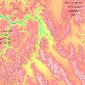
Nombre: Mapa topográfico Lemhi County, altitud, relieve.
Lugar: Lemhi County, Idaho, United States of America (44.22987 -114.82012 45.70598 -112.81246)
Altitud media: 2.146 m
Altitud mínima: 971 m
Altitud máxima: 3.412 m
Otros mapas topográficos
Haga clic en un mapa para ver su topografía, su altitud y su relieve.
Boise
United States of America > Idaho > Boise
Boise, Ada County, Idaho, 83702, United States of America
Altitud media: 1.040 m
Shoshone County
United States of America > Idaho
Shoshone County, Idaho, United States of America
Altitud media: 1.204 m
Ada County
United States of America > Idaho
Ada County, Idaho, United States of America
Altitud media: 1.004 m
Lake Pend Oreille
United States of America > Idaho > Cedar Creek
Lake Pend Oreille, National Forest Development Road 278, Cedar Creek, Bonner County, Idaho, 83803, United States of America
Altitud media: 941 m