
Mapa topográfico Richard-Strauss-Straße
Mapa interactivo
Haga clic en el mapa para ver la altitud.
Acerca de este mapa
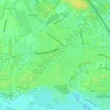
Nombre: Mapa topográfico Richard-Strauss-Straße, altitud, relieve.
Altitud media: 377 m
Altitud mínima: 368 m
Altitud máxima: 386 m
Otros mapas topográficos
Haga clic en un mapa para ver su topografía, su altitud y su relieve.
85049
Deutschland > Bayern > Ingolstadt
85049, West, Ingolstadt, Bayern, Deutschland
Altitud media: 377 m
Dünzlau
Deutschland > Bayern > Ingolstadt > Dünzlauer Mühle
Dünzlau, Dünzlauer Mühle, West, Ingolstadt, Bayern, 85049, Deutschland
Altitud media: 378 m
Niederfeld
Deutschland > Bayern > Ingolstadt
Niederfeld, Südost, Ingolstadt, Bayern, Deutschland
Altitud media: 365 m
Unterbrunnenreuth
Deutschland > Bayern > Ingolstadt
Unterbrunnenreuth, Süd, Ingolstadt, Bayern, Deutschland
Altitud media: 369 m
Irgertsheim
Deutschland > Bayern > Ingolstadt
Irgertsheim, West, Ingolstadt, Bayern, Deutschland
Altitud media: 385 m
Zuchering
Deutschland > Bayern > Ingolstadt > Zuchering
Zuchering, Ingolstadt, Bayern, 85051, Deutschland
Altitud media: 370 m
Gerolfing Nord
Deutschland > Bayern > Ingolstadt > Gerolfing Nord
Gerolfing Nord, West, Ingolstadt, Bayern, 85049, Deutschland
Altitud media: 374 m