
Haz una donación
Mapa topográfico Pincher Creek (town)
Haga clic en el mapa para ver la altitud.
Haz una donación
Acerca de este mapa
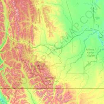
Nombre: Mapa topográfico Pincher Creek (town), altitud, relieve.
Lugar: Pincher Creek (town), Alberta, T0K 1W0, Canada (48.78963 -114.64715 50.18963 -113.24715)
Altitud media: 1.435 m
Altitud mínima: 827 m
Altitud máxima: 3.135 m
Haz una donación
Otros mapas topográficos
Haga clic en un mapa para ver su topografía, su altitud y su relieve.
Calgary
Calgary, Alberta, is uniquely positioned in the transition zone between the rolling Canadian Prairies to the east and the rugged foothills of the Canadian Rockies to the west, creating a landscape of undulating hills, plateau-like uplands, and deep river valleys. The Bow and Elbow Rivers carve prominent bluffs…
Altitud media: 1.106 m
Edmonton
Edmonton is on the North Saskatchewan River, at an elevation of 671 m (2,201 ft). It is North America's northernmost city with a metropolitan population over one million. It is at the same latitude as Hamburg (Germany); Dublin (Ireland); Manchester (United Kingdom); and Magnitogorsk (Russia). It is south of…
Altitud media: 690 m
Haz una donación
Fort McMurray
Canada > Alberta > Wood Buffalo
The community lies at a lower elevation than most other parts of Alberta, so under the right conditions it can be a "hot spot" for Alberta.
Altitud media: 345 m
Haz una donación
Banff
Banff is a town within Banff National Park in Alberta, Canada. It is located in Alberta's Rockies along the Trans-Canada Highway, approximately 126 km (78 mi) west of Calgary and 58 km (36 mi) east of Lake Louise. At 1,400 to 1,630 m (4,590 to 5,350 ft) above sea level, Banff is the community with the second…
Altitud media: 1.421 m
Nose Hill Park
Names currently associated with topographical features in and near Nose Hill Park reflect the impact of the European newcomers and European trade goods on the Peigan. For example, Spy Hill, the westward extension of Nose Hill, derived its present name from the aboriginal practice of communicating with distant…
Altitud media: 1.174 m
Town of Cochrane
Cochrane is situated at the base of Big Hill in the Bow River Valley. It sits at an elevation of 1,186 m (3,891 ft). The town is intersected by Highway 1A and Highway 22. Cochrane has a reputation for its western culture, which can easily be felt when one wanders the streets (particularly Main Street). The…
Altitud media: 1.200 m
Haz una donación
Whitecourt
Whitecourt is a town in Northern Alberta, Canada that is surrounded by Woodlands County. It is approximately 177 km (110 mi) northwest of Edmonton and 279 km (173 mi) southeast of Grande Prairie at the junction of Highway 43 and Highway 32. It has an elevation of 690 m (2,260 ft).
Altitud media: 719 m
Haz una donación
Lethbridge
Its high elevation of 929 m (3,048 ft) and close proximity to the Rocky Mountains provides Lethbridge with cooler summers than other locations in the Canadian Prairies. These factors protect the city from strong northwest and southwest winds and contribute to frequent chinook winds during the winter.…
Altitud media: 907 m
Haz una donación
Haz una donación
Grande Prairie
Grande Prairie is located just north of the 55th parallel north, and is 465 km (289 mi) northwest of Edmonton, lying at an elevation of 669 metres (2,195 ft) above sea level. The city is surrounded by farmland to the north, east, and west. To the south lies a vast boreal forest with aspen, tamarack, lodgepole…
Altitud media: 665 m
Haz una donación
Haz una donación
Haz una donación
Waterton Lakes National Park
Canada > Alberta > Improvement District No. 04
Operated by Parks Canada, Waterton is open all year, but the main tourist season is during July and August. The only commercial facilities available within the park are located at the Waterton Park townsite. This park ranges in elevation from 1,290 metres (4,232 ft) at the townsite to 2,910 m (9,547 ft) at…
Altitud media: 1.778 m
Haz una donación
Town of Fox Creek
Fox Creek is a town in northwest Alberta, Canada. It is located on Highway 43, approximately 259 km (161 mi) northwest of Edmonton and 199 km (124 mi) southeast of Grande Prairie, and has an elevation of 808 m (2,651 ft).
Altitud media: 824 m
Haz una donación
Rocky Mountain House
Canada > Alberta > Rocky Mountain House
Rocky Mountain House has a subarctic climate (Köppen climate classification Dfc) that borders on a humid continental climate (Köppen Dfb). Daytime temperatures are in general representative for the latter, but the larger diurnal temperature variation with the high elevation ensures frequent frosts. The…
Altitud media: 988 m
Haz una donación
Haz una donación
Banff National Park
Banff National Park has a subarctic climate with three ecoregions, including montane, subalpine, and alpine. The forests are dominated by Lodgepole pine at lower elevations and Engelmann spruce in higher ones below the treeline, above which is primarily rocks and ice. Mammal species such as the grizzly bear,…
Altitud media: 1.848 m
Haz una donación
Haz una donación
Haz una donación
Haz una donación
Haz una donación
Town of Barrhead
The area contains dense stands of spruce, birch, pine and poplar. It also has some of the most fertile farmland in the province and is located between two major rivers, the Athabasca River and Pembina River. The Paddle River, a tributary of the Pembina River, flows directly through the town Barrhead. If you go…
Altitud media: 652 m
Haz una donación
Haz una donación
Haz una donación
Haz una donación
Haz una donación
Haz una donación
Haz una donación