
Haz una donación
Mapa topográfico Lethbridge
Haga clic en el mapa para ver la altitud.
Haz una donación
Lethbridge
Its high elevation of 929 m (3,048 ft) and close proximity to the Rocky Mountains provides Lethbridge with cooler summers than other locations in the Canadian Prairies. These factors protect the city from strong northwest and southwest winds and contribute to frequent chinook winds during the winter. Lethbridge winters have the highest temperatures in the prairies, reducing the severity and duration of winter cold periods and resulting in fewer days with snow cover. The average daytime temperature peaks by the end of July/beginning of August, when it reaches 26.4 °C (79.5 °F). The city's temperature reaches a maximum high of 35.0 °C (95.0 °F) or greater on average once or twice a year.
Haz una donación
Acerca de este mapa
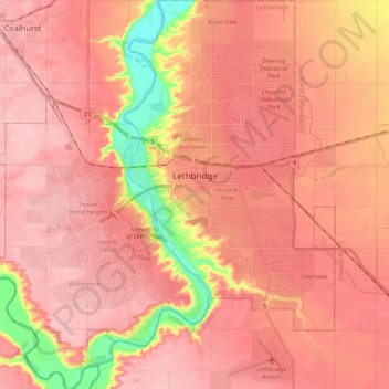
Nombre: Mapa topográfico Lethbridge, altitud, relieve.
Lugar: Lethbridge, Alberta, Canada (49.61885 -112.94967 49.75651 -112.75663)
Altitud media: 907 m
Altitud mínima: 814 m
Altitud máxima: 944 m
Haz una donación
Otros mapas topográficos
Haga clic en un mapa para ver su topografía, su altitud y su relieve.
Haz una donación
Haz una donación
Medicine Lake
Canada > Alberta > Division No. 15
Wildlife is surprisingly abundant along this high altitude lake. Grizzly bear, black bear, mule deer, caribou, wolves, moose and mountain sheep are some of the larger mammals that frequent the lake area during the summer season. Bald eagles, and osprey also frequent the area and live off the fish populations.
Altitud media: 1.681 m
Maligne Canyon
Canada > Alberta > Division No. 15 > Municipality of Jasper
While visually striking and unusual, slot canyons are a common occurrence within the northern Rocky Mountains. These canyons show the characteristics of karst topography and are common in this region due to the easily soluble nature of the limestone. Flowing out of Medicine Lake, the Maligne River flows about…
Altitud media: 1.134 m
Haz una donación
Haz una donación