
Mapa topográfico Kos
Mapa interactivo
Haga clic en el mapa para ver la altitud.
Acerca de este mapa
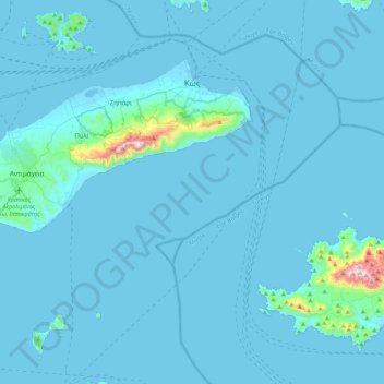
Nombre: Mapa topográfico Kos, altitud, relieve.
Lugar: Kos, Kos Regional Unit, South Aegean Region, Aegean, Greece (36.67169 26.91719 36.91616 27.35599)
Altitud media: 25 m
Altitud mínima: -5 m
Altitud máxima: 827 m
Otros mapas topográficos
Haga clic en un mapa para ver su topografía, su altitud y su relieve.
Oia
Greece > Aegean > Thira Regional Unit > Ia Municipal Unit
The village is located on top of a hill, at about 150 m (500 ft) elevation, and known as the "Eagles nest" from where Palia and Nea Kameni volcanoes are seen and also the island of Therasia. It is situated to the north of the island and Fira is at distance of 11 km (7 mi). The main street in the town, in the…
Altitud media: 20 m
Fanes
Greece > Aegean > Rhodes Regional Unit
Fanes (Greek: Φάνες) is a village in the northeast part of Rhodes. The main village is situated around 1 km inland, at an average elevation of 46 meters above the sea level.
Altitud media: 46 m