
Mapa topográfico Al Wakrah
Mapa interactivo
Haga clic en el mapa para ver la altitud.
Acerca de este mapa
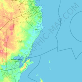
Nombre: Mapa topográfico Al Wakrah, altitud, relieve.
Lugar: Al Wakrah, Qatar (24.47482 51.08735 25.21982 52.23649)
Altitud media: 11 m
Altitud mínima: -2 m
Altitud máxima: 101 m
Previously, Al Wakrah's largest mosque was Al Ayouni Mosque, constructed around 1935. It was built near the coast because it was the most active and populated section of the city. After a new mosque was built closer to the main road, the mosque became defunct. It has a square shape, measures 16 m by 17 m, and lies 67 cm above ground elevation. A rare characteristic of the mosque is its single entrance on the east side; a majority of other mosques in Qatar constructed during this period had three entrances. The outdoor praying area is accessible from five pathways separated by narrow columns. Adjacent to this is the prayer hall, which can be accessed from three different entrances in the outdoor area.
Otros mapas topográficos
Haga clic en un mapa para ver su topografía, su altitud y su relieve.
Oxygen Park
Oxygen Park, Education City, Al Rayyan, Qatar
Altitud media: 13 m
al Koot Fort
al Koot Fort, Jasim Bin Mohammed Street, Al Jasra, Doha, Qatar
Altitud media: 9 m
Fereej Al Manseer
Fereej Al Manseer, Al Rayyan, Ar Rayyan, 93035, Qatar
Altitud media: 26 m
Qurayn Abu al Bawl
Qurayn Abu al Bawl, Jariyan Al Batnah, Qatar
Altitud media: 76 m