
Mapa topográfico Al Rayyan
Mapa interactivo
Haga clic en el mapa para ver la altitud.
Acerca de este mapa
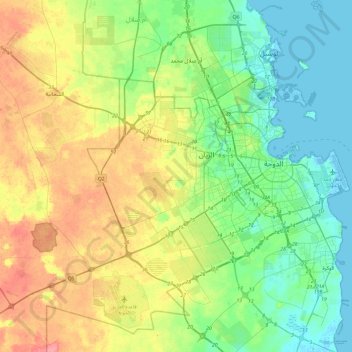
Nombre: Mapa topográfico Al Rayyan, altitud, relieve.
Lugar: Al Rayyan, Qatar (24.47075 50.79549 25.39018 51.54099)
Altitud media: 37 m
Altitud mínima: -2 m
Altitud máxima: 143 m
Similar to many other names given to Qatari settlements and municipalities, Al Rayyan Municipality was named after a geographic feature present in its namesake, the city of Al Rayyan. The city derives its name from the Arabic term "ray", which translates to "irrigation". This name was bestowed upon it due to its low elevation, allowing it to act as a flood plain and provide a sustained supply of water to the numerous plants that grew within its boundaries.
Otros mapas topográficos
Haga clic en un mapa para ver su topografía, su altitud y su relieve.
Oxygen Park
Oxygen Park, Education City, Al Rayyan, Qatar
Altitud media: 13 m
al Koot Fort
al Koot Fort, Jasim Bin Mohammed Street, Al Jasra, Doha, Qatar
Altitud media: 9 m
Fereej Al Manseer
Fereej Al Manseer, Al Rayyan, Ar Rayyan, 93035, Qatar
Altitud media: 26 m
Qurayn Abu al Bawl
Qurayn Abu al Bawl, Jariyan Al Batnah, Qatar
Altitud media: 76 m